**IMPORTANT PARK NOTICES**
Monitor local surf and weather reports prior to your park visit.
•
[KAUAʻI] UPDATED 4/16/24 – Kalalau Trail, Nāpali Coast SWP has REOPENED and the Kauai Northshore Shuttle to Ha’ena SP has RESUMED.
•
[O’AHU] UPDATED 4/18/24 – Vehicle access road in the Mokuleʻia Section of Ka’ena Point State Park is CLOSED due to road conditions. Keawa’ula Section of Ka’ena Point State Park: water pump down; comfort station closed; portable toilets available.
•
[KAUAʻI] UPDATED 3/18/24 – Kōkeʻe State Park: The gate to Puʻu O Kila Lookout will be closed to vehicular traffic due to road repairs beginning 3/19/24. The lookout will still be accessible by pedestrians, parking is available at Kalalau lookout.
Kapaʻeleʻele Trail
| Trail Length | 1.2 miles (round trip) |
| Activity | Pedestrian |
| Difficulty | Easy to Moderate |
| Terrain | Forested and Open Slopes |
| Elevation Gain | 130 ft |
| Park Name | Ahupuaʻa ʻO Kahana State Park |
Description
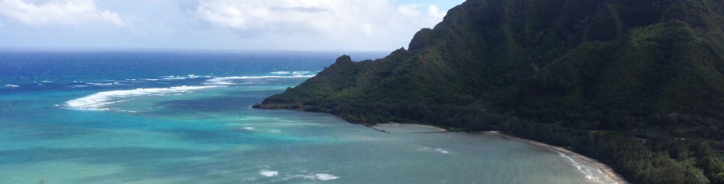
This trail consists of a 1.2 mile loop on the mountain slope along the western side of Kahana Bay. This trail offers stunning views of Kahana Bay, Huilua Fishpond and passes two important cultural sites related to fishing in the bay, Kapa‘ele‘ele Ko‘a (fishing shrine) and Keaniani Kilo (lookout). Take the time to sit on the park bench along the trail to enjoy the view. Look across the bay for the rock walls of Huilua Fishpond. Built by Hawaiians in the late 1600s, these walls enclose 7 acres of ocean where fish were raised and harvested.
Much of the trail is covered with a canopy of native and introduced trees with the Java Plum tree being the most common. But the trail can still be hot and humid, so water is recommended. Portions of the trail contain exposed tree roots and there are steep drop-offs to the side of the trail. Hike with caution and wear appropriate footwear. Expect mosquitoes and allow about an hour for the hike.
Route
Park at the Orientation Center and the trail begins on the dirt road by the parking lot. This road corresponds to the former railroad bed for the Ko‘olau Railway that hauled sugar cane grown in Kahana to the Kahuku sugar mill in the late 1800’s. From the roadway, the trail climbs a gradual slope to an elevation of 150 feet. The side trail to the kilo site is not signed, but is marked by a grove of ironwoods trees on the upslope side of the trail just past the ko‘a. From this point, the trail drops back down to Kamehameha Highway. This section of the trail is very steep and can be slippery. Follow the highway back to the park entry.
Directions
From Honolulu, follow Likelike Highway (Route 83) or H-3 over the Ko‘olau Mountains and take the Kahekili Highway cut-off. Kahekili becomes Kamehameha Highway (Route 830). Go through Ka‘a‘awa town and the entry to Kahana State Park is in the coconut grove near the center of Kahana Bay.
Additional Info
- Mountain biking is not allowed on this trail.
- Stay on the trail.
- Keep dogs on leash.
- Pack out at least what you pack in.
- No open fires.
Kapa‘ele‘ele Ko‘a
A ko‘a is a shrine dedicated to fishing. Hawaiians made offerings here to ensure bountiful harvests of the akule fish (Bigeye scad). The offering was often the first fish caught. The akule is an important food fish that schools in Kahana Bay in large numbers. This ko‘a is a rectangular alignment of boulders that is open toward the sea.
The name Kapa‘ele‘ele literally means “black cloth”. Kapa is Hawaiian cloth made from the bark of the wauke tree (paper mulberry). The name of the ko‘a may be a reference to a god or a specific ritual associated with offering given here.
The site has deteriorated over time, and we ask that you help us to preserve the site by remaining on the trail and not entering the shrine.
Please do not disturb the stones or leave rock wrapped in ti leaves. This is not an appropriate offering.
Keaniani Kilo
This spot served as a lookout (kilo) for fishermen. From here, the kilo i‘a (fish watcher) could spy schools of akule fish which would sparkle as the sun reflected off of them like a mirror (aniani). He would then direct a group of waiting fishermen in canoes via a set of signals using a pole with a flag of white kapa. The fishermen would then surround the school of fish with their nets, and villagers of all ages would gather on the shore to hukilau (pull in the nets). The catch was then divided equally between all participants. Additionally, a malihini (guest) share was set aside for any passers by or visitors who were watching, an early example of what is today known as the “Aloha spirit”.
A second kilo was located at about the same elevation on the opposite side of the bay. The time of day determined which lookout was used, taking advantage of the sun’s position.
Activities
Facilities
Hazards
Prohibited
Area Weather Forecast
