**IMPORTANT PARK NOTICES**
⚠️ Always monitor weather reports and ocean conditions before your park visit.
•
[KAUAʻI] 7/8/26
The Kalalau Trail, Nāpali Coast State Wilderness Park has REOPENED.
•
[MAUI] UPDATE 7/7/26
‘Iao Valley State Monument: Will be CLOSED until July 24, 2026 for safety improvements.
•
[O’AHU] 7/6/26
The Royal Mausoleum State Monument will be closed on July 7, and July 8, 2026 for John Young Tomb maintenance and repair
•
[MAUI] 7/1/26
Beginning today, July 1, 2026 through March 2027, all camper van camping reservations at Waiʻānapanapa State Park will be temporarily unavailable due to construction of the park's new comfort station.
•
[KAUA’I] UPDATE 6/23/26
The Puu Hina Hina Parking Lot remains closed due parking lot striping.
•
[MAUI] UPDATE 6/22/26
Polipoli Spring State Recreation Area: Polipoli cabins and camping areas are CLOSED until further notice.
•
[KAUA’I] UPDATED 5/27/26
Kalalau Trail from mile marker 2-11 after Hanakapiai Valley, will be CLOSED for a feral animal control hunt from June 1-4. The 2 miles of the trail from Keʻe beach at Haʻena State Park to Hanakapiai falls will remain open during this time.
—
Puʻu Hinahina parking lot will be CLOSED for road work from May 25-29 and again from June 15-19.
—
Koke’e State Park camping will be CLOSED for campground improvements. Construction to begin May 2026 and extend through Spring 2027.
—
Pāʻulaʻula State Historic Site: CLOSED for construction.
•
[O’AHU] UPDATED 6/10/26
Heʻeia State Park partial parking lot road closure due to landslide and upcoming stabilization work.
—
Wahiawā Freshwater State Recreation Area: Portions of the park which access the reservoir (Also known as Lake Wilson) will be closed Sunday, May 3, 2026 at 1 a.m. the park will remain open to visitors for onshore activities, but lake access via the boat ramp, reservoir banks, and reservoir shores will not be allowed until further notice.
—
Ka’ena Point State Park, Mākua Section has REOPENED to beach access. The Keawa’ula section remains CLOSED due to road repairs and damage due to the recent Kona Low storms. The Mokule’ia vehicle access road has REOPENED to valid permit holders - note some roads previously accessible have been closed due to storm damage - heed all road signs.
•
•
[HAWAI’I] UPDATED 4/10/26
Notice to bidders for Mobile Food Truck Concessions opened today for certain Hawai’i Island parks. More information at: https://dlnr.hawaii.gov/dsp/announcements/mobile-food-truck-concessions-hawaii/
—
Akaka Falls State Park: Water and comfort station CLOSED, park open with portable toilets.
Diamond Head Summit Trail
| Trail Length | 1.6 miles (round trip) |
| Time | 2 hours |
| Activity | Pedestrian |
| Difficulty | Moderate |
| Terrain | Hot, Dry, Slopes |
| Elevation Gain | 560 ft |
| Trail Brochure | Diamond Head State Monument |
| Park Name | Diamond Head State Monument |
Description
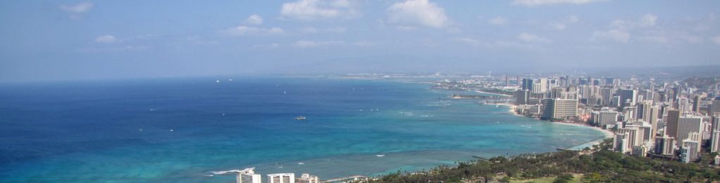
The trail to the summit of Leʻahi (Hawaiian name for Diamond Head Crater) was built in 1908 as part of Oʻahu’s coastal defense system. Completed in 1911, the Fire Control Station at the summit directed artillery fire from batteries in Waikiki and Fort Ruger outside Diamond Head crater. The walk is a glimpse into the geological and military history of this volcanic crater. Much of the trail is a natural tuff surface with many switchbacks traversing the steep interior slope of the crater wall. The ascent continues up steep stairs and through a lighted 225-foot tunnel. At the summit, you’ll see bunkers on the crater rim and a navigational lighthouse built in 1917 along the coast outside the crater. The postcard view of the shoreline of southeastern Oʻahu from Koko Head to Wai’anae is stunning, and during winter, may include passing humpback whales.
Route
From the parking lot on the crater floor, the trail to the summit is 0.8 mile (1.3 km) one way and climbs 560 feet (171 m) in elevation. There is a paved concrete walkway for a distance of 0.2 miles at the start of the hike, but the trail becomes uneven and steep, requiring caution and appropriate footwear. Portions of the trail involve steep stairways – take your time. Another portion of the trail goes through a long, narrow tunnel which is lighted.
Directions
The trailhead is adjacent to the parking lot within Diamond Head State Monument. The entrance is off Diamond Head Road between Makapu’u Avenue and 18th Avenue, Honolulu. See park page for fees. (Click Here)
Additional Info
- Mountain biking is not allowed on this trail.
- Stay on the trail.
- NO DOGS ALLOWED IN DIAMOND HEAD STATE MONUMENT.
- Pack out at least what you pack in.
- No open fires.
- Hiking permit not required for groups less than 25.
Activities
Facilities
Hazards
Prohibited
Area Weather Forecast

