**IMPORTANT PARK NOTICES**
⚠️ Always monitor weather reports and ocean conditions before your park visit.
•
[KAUA’I] UPDATE 6/23/26
The Puu Hina Hina Parking Lot remains closed due parking lot striping.
•
[MAUI] UPDATE 6/22/26
‘Iao Valley State Monument: Will be CLOSED until July 17, 2026 for safety improvements.
–
Polipoli Spring State Recreation Area: Polipoli cabins and camping areas are CLOSED until further notice.
•
[O’AHU] UPDATED 6/18/26
There will be an early closure at 5PM HST on Saturday July 4, 2026 for Puʻu ʻUalakaʻa State Wayside (ʻUalakaʻa Trail) due to \\\\\\\\\\\\\\\"Fireworks Prohibited in the State Parks\\\\\\\\\\\\\\\"
•
[HAWAI’I] UPDATE 6/17/26
There will be an early closure at 5PM HST on Saturday July 4, 2026 for the West Hawaii State Parks (Kekaha Kai (Manini Owali & Mahai’ula), Kiholo, Hapuna SRA (Hapuna & Waialea) due to \\\\\\\\\\\\\\\"Fireworks Prohibited in the State Parks\\\\\\\\\\\\\\\"
•
[KAUA’I] UPDATED 5/27/26
Kalalau Trail from mile marker 2-11 after Hanakapiai Valley, will be CLOSED for a feral animal control hunt from June 1-4. The 2 miles of the trail from Keʻe beach at Haʻena State Park to Hanakapiai falls will remain open during this time.
—
Puʻu Hinahina parking lot will be CLOSED for road work from May 25-29 and again from June 15-19.
—
Koke’e State Park camping will be CLOSED for campground improvements. Construction to begin May 2026 and extend through Spring 2027.
—
Pāʻulaʻula State Historic Site: CLOSED for construction.
•
[O’AHU] UPDATED 6/10/26
Heʻeia State Park partial parking lot road closure due to landslide and upcoming stabilization work.
—
Wahiawā Freshwater State Recreation Area: Portions of the park which access the reservoir (Also known as Lake Wilson) will be closed Sunday, May 3, 2026 at 1 a.m. the park will remain open to visitors for onshore activities, but lake access via the boat ramp, reservoir banks, and reservoir shores will not be allowed until further notice.
—
Ka’ena Point State Park, Mākua Section has REOPENED to beach access. The Keawa’ula section remains CLOSED due to road repairs and damage due to the recent Kona Low storms. The Mokule’ia vehicle access road has REOPENED to valid permit holders - note some roads previously accessible have been closed due to storm damage - heed all road signs.
•
[MOLOKAʻI] UPDATE 4/20/26
Pālāʻau State Park: Pālāʻau Wayside Pavilion and Campgrounds remain CLOSED until further notice.
•
[HAWAI’I] UPDATED 4/10/26
Notice to bidders for Mobile Food Truck Concessions opened today for certain Hawai’i Island parks. More information at: https://dlnr.hawaii.gov/dsp/announcements/mobile-food-truck-concessions-hawaii/
—
Akaka Falls State Park: Water and comfort station CLOSED, park open with portable toilets.
Kaʻena Point Trail
| Trail Length | 2.5 miles |
| Activity | Pedestrian, Biking |
| Difficulty | Moderate |
| Terrain | Open Coastline |
| Elevation Gain | Negligible |
| Park Name | Kaʻena Point State Park |
Description
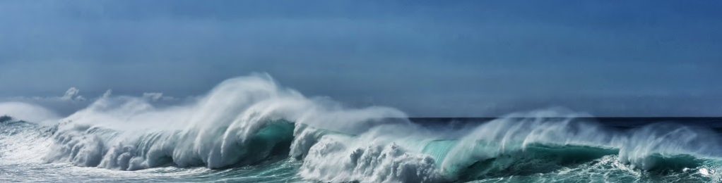
The trail to Ka‘ena Point follows an old railroad bed and former dirt road that ran along the westernmost point of O‘ahu. The trail leads to Ka‘ena Point Natural Area Reserve, a remote and scenic protected area harboring some of the last vestiges of coastal sand dune habitat on the island, and home to native plants and seabirds. Whales frequent this shoreline during the winter months.
The weather is usually sunny and hot, and it can be windy – a hat, sunscreen, and plenty of water are recommended. Allow 1 to 3 hours depending on your pace. Stay away from the wave-exposed coast unless you are familiar with hazardous ocean conditions.
Route
There are two routes to Kaʻena Point. From the Wai‘anae side, take the trailhead at the end of the paved road in the Keawaula Section of Ka‘ena Point State Park and follow the dirt roadway for 2.5 miles to Ka‘ena Point Natural Area Reserve. This route follows the shoreline on your left (southwest), characterized by boulder beaches and occasional tidepools, while cliffs rise above you on your right (northeast). Midway along the trail are a pair of small blowholes. In places the old road has eroded completely.
From the Mokule‘ia side, park at the end of the paved road and follow the dirt roadway for 2.5 miles. The trail traverses a broad, relatively flat coastal plain marked by a raised limestone reef and sand dunes. Upon reaching the Natural Area Reserve, please take care to avoid damaging native flora and watch for nesting seabirds, some of whom make burrow nests. A navigational light is visible at the point. Stay on established paths. No dogs or other animals are allowed in the Park and in the Reserve. To return, retrace your path.
Directions
If you use the Wai‘anae route from Honolulu, take the H1 freeway west, it will eventually turn into Farrington Highway (Route 93). Farrington Highway will become a two lane road at it’s northern end, and terminates at Ka‘ena Point State Park. If you use the Mokule‘ia route, take H-2 to Kaukonahua Road (Route 803) to Farrington Highway (Route 930) past Waialua and go about 1 mile past Camp Erdman. The trailhead on either side of Ka‘ena Point begins where the paved road ends and a rough 4-wheel drive road begins.
Additional Info
- NO ANIMALS ALLOWED IN THE PARK OR KA‘ENA POINT NATURAL AREA RESERVE EXCEPT SERVICE ANIMALS.
- Stay on the trail.
- Pack out at least what you pack in.
- Drones are not permitted.
- No open fires.
Malama Hawaii-Wildlife from Hawaii DLNR on Vimeo.
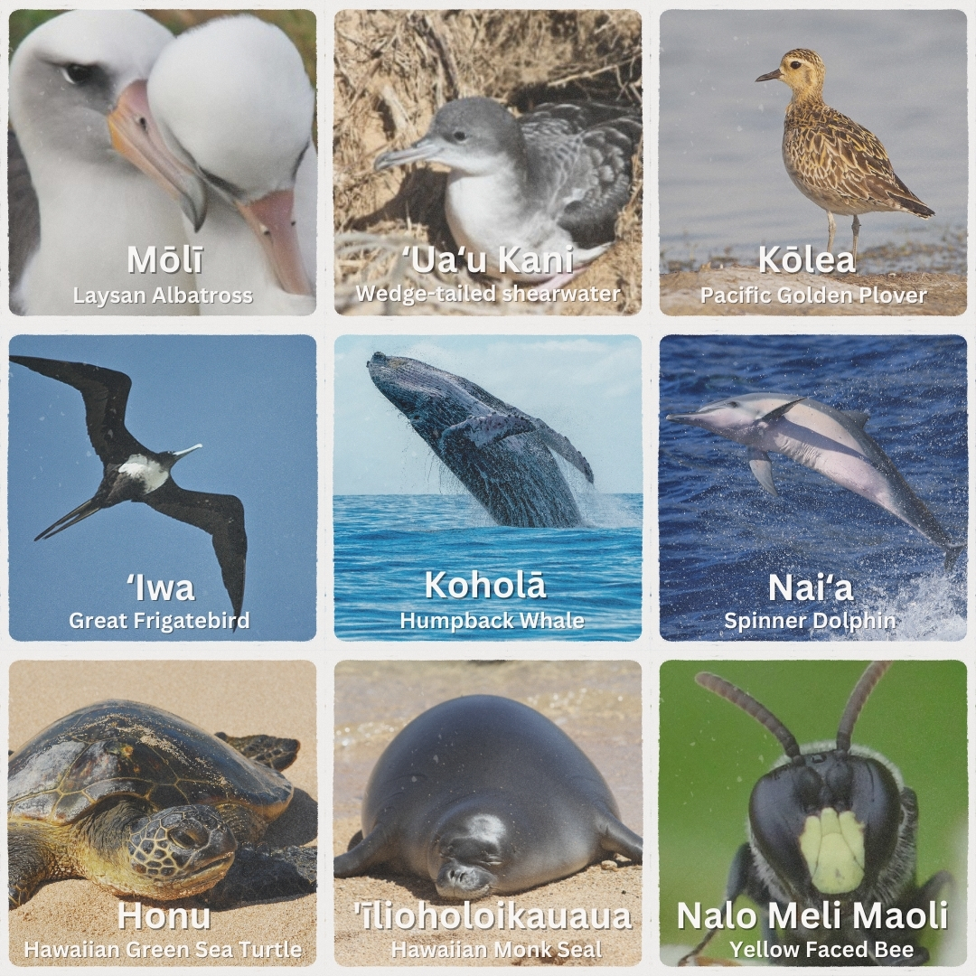
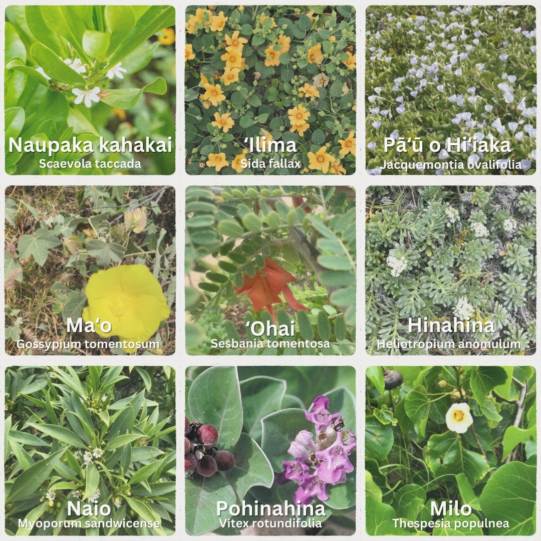
Some Native Plants & Animals of Kaʻena
Hike & Steward
As you hike Kaʻena Point State Park, keep an eye out for the new Marine Debris Drop-off Stations signs pictured below.
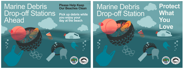 Marine debris consists of man-made objects cast adrift in the ocean, either washed into the water from land-based sources or discarded from vessels at sea. In Hawaiʻi, marine debris drifts in to our waters and comes ashore all year. Marine debris of any size poses a threat to the health and safety of the human population and the fringing coral reef that protects our shorelines. Marine debris may cause entanglement to seabirds, sea turtles, and marine mammals. All marine species could also potentially digest the material.
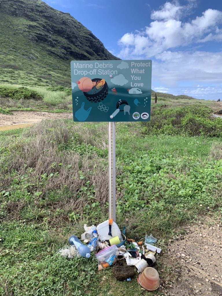
Several signs are visible near the coastal roads and trails. We ask that park users place marine debris found a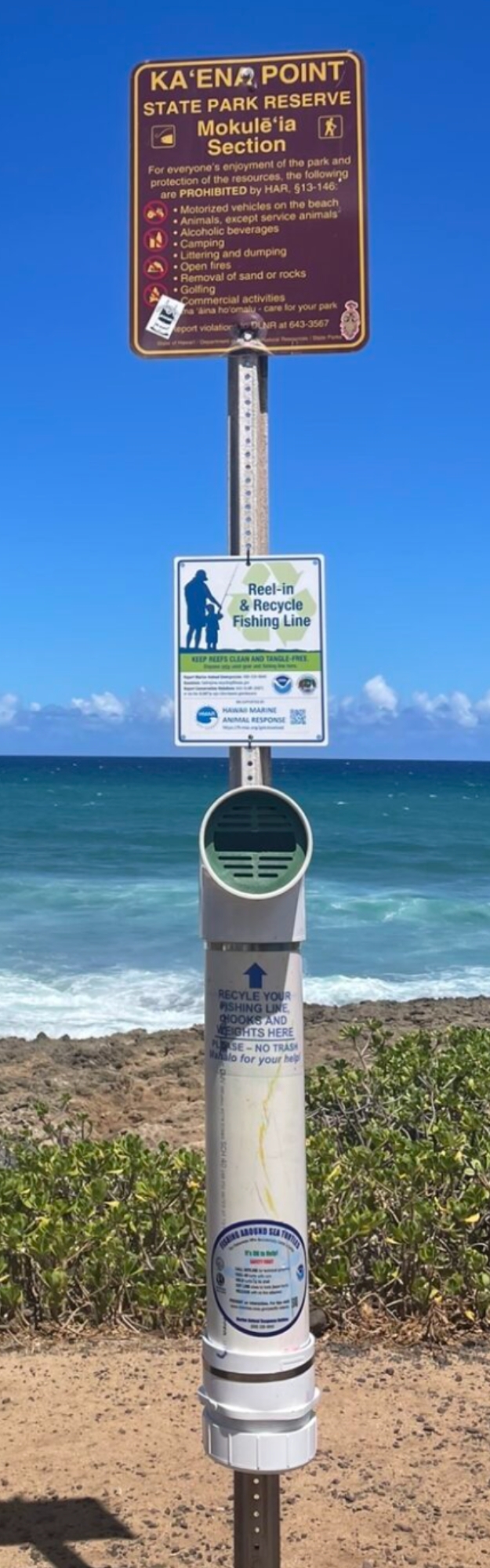 long the shoreline beneath these signs for staff removal, as they serve as Marine Debris Drop-off Stations. Please refrain from leaving trash at these Drop-off Stations, remember to pack out your garbage. As a courtesy reminder, please adhere to all park rules, i.e. no dogs, no drones, no camping.
Kaʻena is traditionally known for its marine resources. Fishers that use the park should properly dispose of their derelict fishing line in the fishing debris collection bins installed in the park by NOAA partner Hawaiʻi Marine Animal Response. The bins are used to collect used line and hooks so that they can be recycled or disposed of properly preventing derelict fishing gear from entering the ocean from the park.
If you would like to get involved and volunteer in the park, scan the QR code or Register As A Volunteer Here.
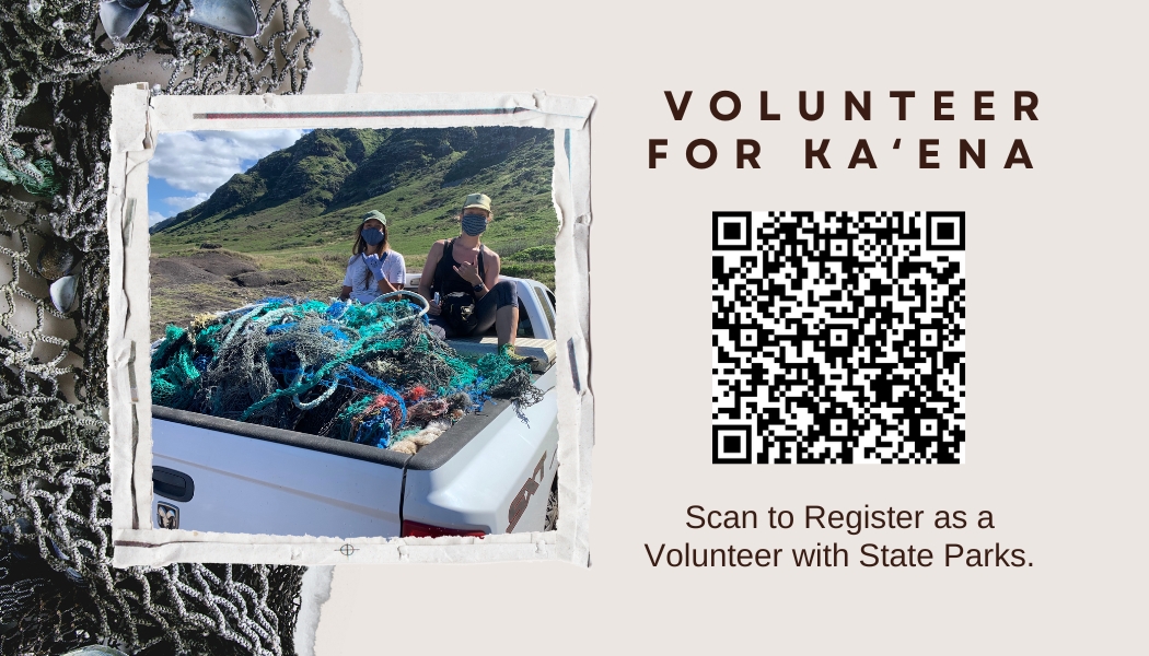 Let’s Protect What We Love and mālama Kaʻena Point State Park. Mahalo.
Activities
Facilities
Hazards
Prohibited
Area Weather Forecast

