**IMPORTANT PARK NOTICES**
⚠️ Monitor weather reports and ocean conditions before your park visit.
•
[STATEWIDE] UPDATE 3/12/26 – All State Parks and Recreation Areas on all Islands, as well as State Park Offices, will be closed as of Friday, 3/13 for public safety. A severe storm is expected to bring flooding rain, high winds, and thunderstorms to most of the State from through the weekend. Please check weather reports and check back frequently for storm closure updates.
•
[HAWAIʻI] UPDATE 3/5/26 – ʻAKAKA FALLS STATE PARK: Dept. of Water Supply shut off water in the area until further notice affecting the park.
•
[O‘AHU] UPDATE 3/4/26 - KA‘ENA POINT STATE PARK, MOKULE‘IA SECTION, VEHICLE ACCESS GATE: Will REOPEN today [UPDATE 3/12 - temporarily closed due to storm]. You need the 2026 Gold decal adhered to the rear of your vehicle to enter the park, the accompanying permit account provides access to the gate combination online. The 2024-2025 Purple decals are no longer valid. Apply for a 2026 Kaʻena Point Vehicle Access Permit here. All applicants must create a NEW account and apply as a new applicant. We are experiencing significant delays in processing, we appreciate your continued patience. Vehicle access dirt road repairs are occurring to stabilize severe erosion, and armor problem areas with aggregate to reduce erosion and puddling, and improve road stability.
•
[KAUAʻI, OʻAHU, HAWAIʻI] 2/10/26 – Wailua River State Park (Kauaʻi), Ahupuaʻa ʻO Kahana State Park (Oʻahu), Kealakekua Bay State Historical Park (Hawaiʻi): All commercial kayak operators must apply for a Rental Vessel Special Use Permit – Commercial Application, each kayak vessel requires a registered decal. Visit State Parks Permits page here and download and mail in the Rental Vessel Special Use Permit – Commercial Application.
•
[ALL ISLANDS] UPDATE – 12/12/25: Camping - Reservations for February 1, 2026 and beyond available at https://explore.ehawaii.gov, please create an account on Explore Outdoor Hawaiʻi to make a camping reservation.
Waʻahila Ridge Trail
| Trail Length | 2.4 miles |
| Activity | Pedestrian |
| Difficulty | Moderate to Difficult |
| Terrain | Dry, Mountainous, Partly Native Forest |
| Elevation Gain | 500 ft |
| Park Name | Waʻahila Ridge State Recreation Area |
Description
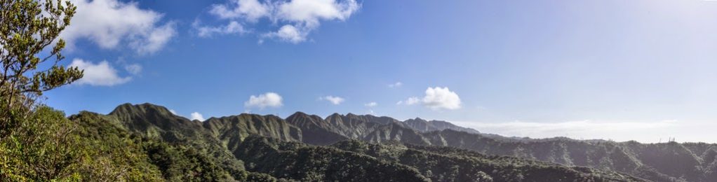
This ridge hike originates in Wa‘ahila Ridge State Recreation Area, and offers great views and viewing of native forest and birdlife.
Route
The trail begins at the back of Wa‘ahila Ridge State Recreation Area within ironwood and guava trees. It traverses alternately between open ridge and forest as it gradually ascends up the ridge between Manoa and Palolo Valleys. It offers spectacular views of Manoa Valley, Palolo Valley, Honolulu and the Ko‘olau Range. Native Hawaiian plants are common along the upper portions of this trail, including koa and ‘ohia lehua. This trail can also be a good place to observe the native birds amakihi and apapane. This trail ends at an intersection with Kolowalu Trail. Do not go up to the summit beyond the Kolowalu/Wa‘ahila junction – it is a Restricted Watershed Area. You may continue down Kolowalu Trail, which descends steeply down into the back of Manoa Valley.
Directions
From Waialae Avenue, proceed up St. Louis Drive. Wind up the road, turning right on Peter St. near the top. At the end of Peter (at the cul-de-sac), turn left on Ruth St., continuing into Wa‘ahila Ridge State Recreation Area. Park in the provided parking lot and follow trailhead signs.
Additional Info
- Mountain biking is not allowed on this trail.
- Stay on the trail.
- Keep dogs on leash.
- Pack out at least what you pack in.
- No open fires.
Activities
Facilities
Hazards
Prohibited
Area Weather Forecast

