**IMPORTANT PARK NOTICES**
Monitor weather reports before your park visit.
•
[KAUA’I] - 1/6/26: Kalalau Trail, Nāpali Coast SWP remains CLOSED due to potential flood conditions.
•
[OʻAHU] 1/5/26 - Kaʻena Point Vehicle Access Permits available now: kaenasups.ehawaii.gov. All applicants must create a NEW account and apply as a new applicant.
•
[OʻAHU] UPDATE 12/15/25 — Ka‘ena Point State Park: Mokulē‘ia Section Vehicle Access Gate is temporarily CLOSED due to saturated road conditions.
•
[ALL ISLANDS] UPDATE – 12/12/25: Camping - Reservations for February 1, 2026 and beyond available at https://explore.ehawaii.gov, please create an account on Explore Outdoor Hawaiʻi to make a camping reservation.
Makapuʻu Point Lighthouse Trail
| Trail Length | 2.0 miles (round trip) |
| Activity | Pedestrian |
| Difficulty | Moderate |
| Terrain | Hot, Dry Slopes |
| Elevation Gain | 500 ft |
| Park Name | Kaiwi State Scenic Shoreline |
Description
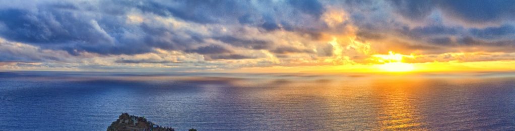
The Makapu‘u Point trail, within Kaiwi State Scenic Shoreline, offers outstanding views of O‘ahu’s southeastern coastline, including Koko Head and Koko Crater. From the trail’s destination at Makapu‘u Head, one is rewarded with magnificent views of the windward coast and offshore islets, as well as the historic red-roofed Makapu‘u Lighthouse built in 1909, which makes a stunning picture against the deep blue sea below (the lighthouse itself is off-limits). On a clear day, you may even see Moloka‘i and Lana‘i. The offshore islets are wildlife sanctuaries for Hawaiian seabirds, such as the ‘iwa, frigate bird, and tropicbird. This trail is an excellent place to view migrating humpback whales in season (November – May). Binoculars are suggested for viewing the whales and seabirds. An interpretive sign and viewing scope along the trail help you view and identify the whales seen from this location.
This portion of the island tends to be hot and dry and the vegetation includes low-growing kiawe and panini (cactus). The trail is exposed and is usually sunny and hot. It can be very windy at the summit. A hat, sunscreen, and plenty of water are recommended. Give yourself about 2 hours to enjoy this hike and it’s wonderful views.
Route
A parking area offers access to the trailhead. Follow the trail as it climbs up the western side of the ridge. Upon reaching the top of the ridge (about the halfway point), the trail switches back to the north, following the eastern side of the ridge. At this point it levels out somewhat, but still climbs gradually to the summit, where a pair of guard-railed lookouts offer panoramic vistas. To return, retrace your route.
Directions
The park and trailhead are located off of the Kalanianaole Highway (Hwy. 72) at the southeastern-most point of Oahu. From Honolulu, take the H1 freeway east until it becomes Highway 72. Follow the road beyond Hawaii Kai, Hanauma Bay and Sandy Beach Park until you reach the park area adjacent to the highway. From the windward side, take the Kalanianaole Highway (Hwy. 72) southeast beyond Kailua, Waimanalo, and Makapu‘u Beach Park, after which the road climbs up toward Makapu‘u Head. The park will be on the left side of the highway.
Additional Info
- Stay on the trail.
- Pack out at least what you pack in.
- No open fires.
Activities
Facilities
Hazards
Prohibited
Area Weather Forecast

