**IMPORTANT PARK NOTICES**
⚠️Monitor weather reports and ocean conditions before your park visit.
•
[O‘AHU] UPDATE 2/20/26 - KA‘ENA POINT STATE PARK, MOKULE‘IA SECTION: Park is CLOSED due to saturated roads and inclement weather. Kaʻena Point Vehicle Access Permits available now. All applicants must create a NEW account and apply as a new applicant. We are experiencing significant delays in processing, we appreciate your continued patience. Vehicle access dirt road repairs are occurring to stabilize severe erosion, and armor problem areas with aggregate to reduce erosion and puddling, and improve road stability.
•
[KAUAʻI, OʻAHU, HAWAIʻI] 2/10/26 – Wailua River State Park (Kauaʻi), Ahupuaʻa ʻO Kahana State Park (Oʻahu), Kealakekua Bay State Historical Park (Hawaiʻi): All commercial kayak operators must apply for a Rental Vessel Special Use Permit – Commercial Application, each kayak vessel requires a registered decal. Visit State Parks Permits page here and download and mail in the Rental Vessel Special Use Permit – Commercial Application.
•
[ALL ISLANDS] UPDATE – 12/12/25: Camping - Reservations for February 1, 2026 and beyond available at https://explore.ehawaii.gov, please create an account on Explore Outdoor Hawaiʻi to make a camping reservation.
Nakoa Trail
| Trail Length | 2.5 mile loop |
| Activity | Pedestrian |
| Difficulty | Moderate to Difficult, includes Stream Crossings |
| Terrain | Wet, Valley Rainforest |
| Elevation Gain | 400 ft |
| Trail Brochure | Nakoa Trail |
| Park Name | Ahupuaʻa ʻO Kahana State Park |
Description
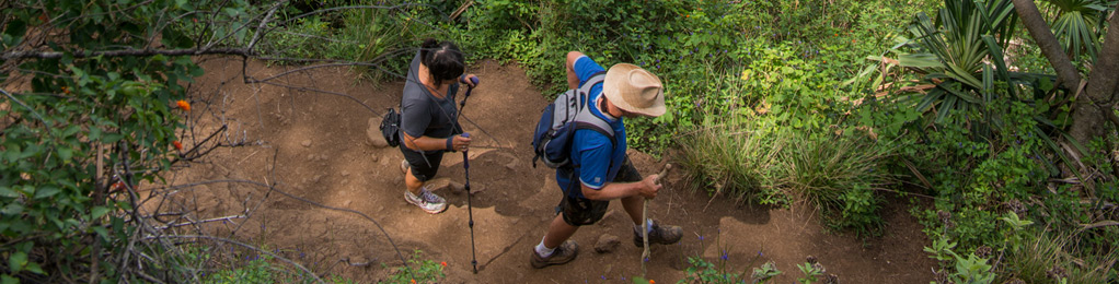
Nakoa Trail is a 2.5 mile loop that traverses the mid-elevation rainforest of Kahana Valley. Named after the native koa tree, the trail meanders through a mixed forest of native plants such as koa, hala (pandanus), and ferns, as well as exotic species such as ink berry, guava and octopus trees. Kahana is the wettest place on O‘ahu which accounts for the lush vegetation and clear flowing streams found along this trail. The military used Kahana as a jungle training site during World War II and you may notice the bunkers and crushed coral roads remaining from this time.
The trail can be very muddy and slippery, with exposed roots and rocks, and should not be attempted during periods of heavy rain or if rain appears imminent. There are several stream crossings that can be dangerous during periods of heavy rain and are subject to flash flooding. Check weather reports before your hike. Mosquitoes are prevalent on this trail. Allow 2-3 hours to complete this hike. Trail is generally covered with a tree canopy, but can be hot and humid, so bring plenty of water. Do not drink the water from the stream.
The trail crosses Kahana stream at three locations. There are no bridges. Two of the crossings are approximately 30 feet wide and the stream bottom is covered with slippery, medium sized boulders. The third crossing is at a dam, and involves walking across a narrow, 40-foot long cement spillway, which can be slippery and have rapid-moving water. All of the stream crossings should only be attempted by sure-footed individuals, and while exercising great care. Do not enter streams if you have open cuts. Harmful bacteria such as Leptospirosis may be present and pose a serious health risk.
Route
Take Kahana Valley Road within the park and proceed past the Park Orientation Building until you reach the residential area indicated by homes. From the designated hiker parking area before the residences, hike up-valley on the paved road, passing around a locked gate, until you come to the hunter/hiker check-in station. Please sign in here. From this location, follow trail arrow about 50 feet to the left to the trailhead. Signs and arrows at prominent locations and intersections will direct you to stay on the main trail. This is important, as many side trails created by wild pigs can easily lead one astray. People commonly become disoriented and lost along this trail system.
Directions
From Honolulu, follow Likelike Highway (Route 83) or H-3 over the Ko‘olau Mountains and take the Kahekili Highway cut-off. Kahekili becomes Kamehameha Highway (Route 830). Go through Ka‘a‘awa town and the entry to Kahana State Park is in the coconut grove near the center of Kahana Bay.
Additional Info
- Mountain biking is not allowed on this trail.
- Stay on the trail.
- Keep dogs on leash.
- Pack out at least what you pack in.
- No open fires.
- Watch for hunters – Portions of the trail are in the public hunting area. Wear bright clothing.
- Hunting is permitted on weekends and State holidays only.
Activities
Facilities
Hazards
Prohibited
Area Weather Forecast

