Monitoring
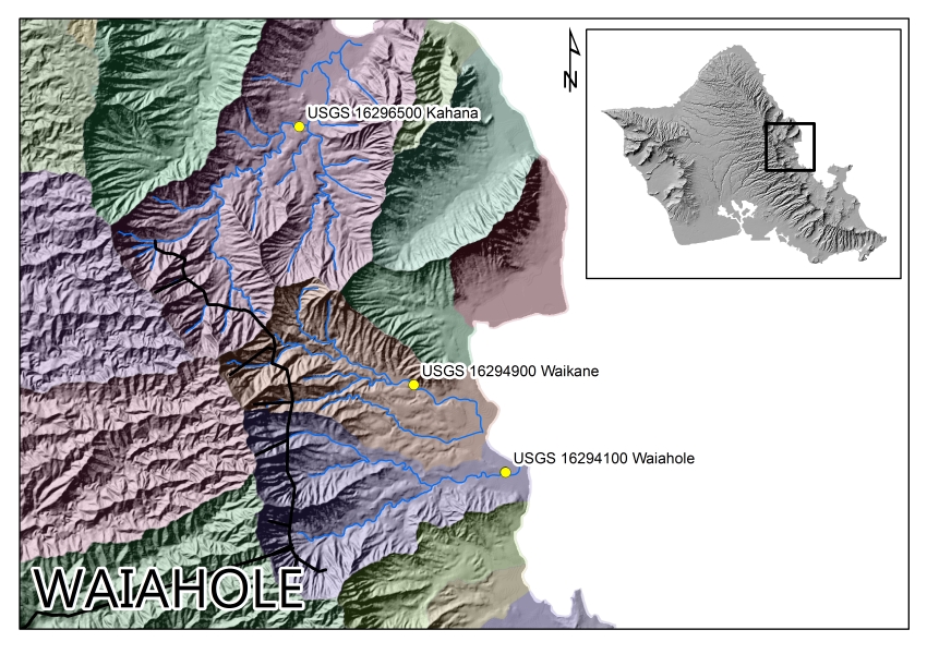
Waiahole Gage Sites
| Kahana at alt 30 ft (USGS ID: 16296500) IIFS: 13.3 mgd |
|||||||||
| 2006 | 2007 | 2008 | 2009 | 2010 | |||||
| 2011 | 2012 | 2013 | 2014 | 2015 | |||||
| Waikane at alt 75 ft (USGS ID: 16294900) IIFS: 3.5 mgd |
|||||||||
| 2006 | 2007 | 2008 | 2009 | 2010 | |||||
| 2011 | 2012 | 2013 | 2014 | 2015 | |||||
| Waiahole above Kamehameha Hwy (USGS ID: 16294100) IIFS: 12.2 mgd |
|||||||||
| 2006 | 2007 | 2008 | 2009 | 2010 | |||||
| 2011 | 2012 | 2013 | 2014 | 2015 | |||||
East Maui Gage Sites
| Honopou nr bridge ds Haiku Ditch (CWRM ID: 6-59) IIFS: 1.29 mgd |
|||||||||
| 2011 | 2012 | 2013 | 2014 | 2015 | 2016 | 2017 | 2018 | ||
| Hanehoi ab Lowrie Ditch (CWRM ID: 6-60) IIFS: 0.74 mgd |
|||||||||
| 2016 | 2017 | 2018 | |||||||
| Palauhulu nr Hana Highway (CWRM ID: 6-61) IIFS: 3.56 mgd (Gage was lost in April 2016. Replacement pending Decision and Order in CCH-MA13-01.) |
|||||||||
| 2011 | 2012 | 2013 | 2014 | 2015 | 2016 | — | |||
| Wailuanui nr Hana Highway (CWRM ID: 6-62) IIFS: 3.05 mgd |
|||||||||
| 2011 | 2012 | 2013 | 2014 | 2015 | 2016 | 2017 | 2018 | ||
| Waiohue nr Hana Highway (CWRM ID: 6-64) IIFS: 2.07 mgd (wet season), 0.06 mgd (dry season) |
|||||||||
| 2011 | 2012 | 2013 | 2015 | 2016 | 2017 | 2018 | |||
| Kopiliula blw Hana Highway (CWRM ID: 6-102) IIFS: 0.32 mgd |
|||||||||
| 2017 | 2018 | ||||||||
| West Wailuaiki nr Hana Highway (CWRM ID: 6-65) IIFS: 2.46 mgd (wet season), 0.26 mgd (dry season) |
|||||||||
| 2011 | 2012 | 2013 | 2014 | 2015 | 2016 | 2017 | 2018 | ||
| East Wailuaiki nr Hana Highway (CWRM ID: 6-66) IIFS: 2.39 mgd (wet season), 0.13 mgd (dry season) |
|||||||||
| 2011 | 2012 | 2013 | 2014 | 2015 | 2016 | 2017 | 2018 | ||
| Waikamoi nr Hana Highway (CWRM ID: 6-67) IIFS: 1.81 mgd (wet season), 0.00 mgd (dry season) |
|||||||||
| 2011 | 2012 | 2013 | 2014 | 2015 | 2016 | 2017 | 2018 | ||
| Makapipi nr Hana Highway (CWRM ID: 6-72) IIFS: 0.60 mgd |
|||||||||
| 2016 | 2017 | 2018 | |||||||
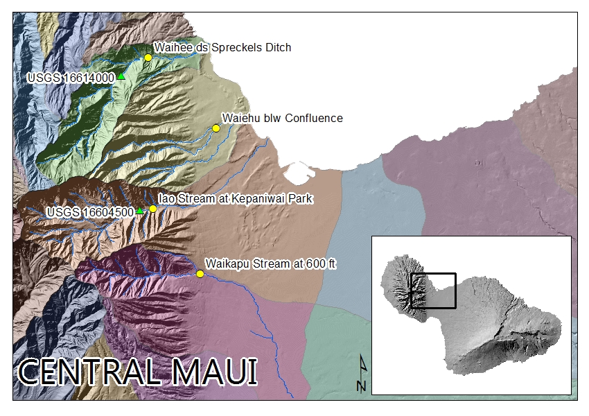
Central Maui Gage Sites
| Waihee ds Spreckels Ditch (CWRM ID: 6-68) IIFS: 10.0 mgd |
|||||||||
| 2011 | 2012 | 2013 | 2014 | 2015 | 2016 | 2017 | |||
| Waiehu blw Confluence (CWRM ID: 6-69) IIFS: 1.8 mgd |
|||||||||
| 2011 | 2012 | 2013 | 2014 | 2015 | 2016 | 2017 | 2018 | ||
| Wailuku at Kepaniwai Park (CWRM ID: 6-85) IIFS: 10.0 mgd (Gage was lost in September 2016 storm event and is pending replacement.) |
|||||||||
| 2015 | 2016 | 2017 | |||||||
| Waikapu at 600ft (CWRM ID: 6-86) IIFS: 2.9 mgd (Gage was lost in September 2016 storm event and is pending replacement.) |
|||||||||
| 2014 | 2015 | 2016 | 2017 | ||||||
| Waikapu at 915ft (CWRM ID: 6-88) IIFS: 2.9 mgd (Gage 6-86 was replaced with Gage 6-88 in late 2017.) |
|||||||||
| 2017 | |||||||||
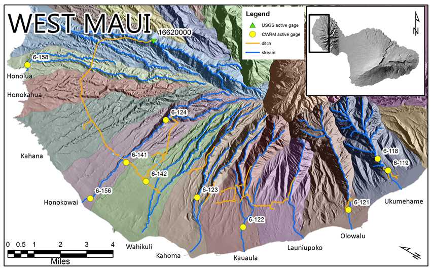
West Maui Gage Sites
| Ukumehame at 180 ft (CWRM ID: 6-119) IIFS: 13.3 mgd |
|||||||||
| 2017 | |||||||||
| Olowalu blw Lower Diversion (CWRM ID: 6-121) IIFS: 3.5 mgd |
|||||||||
| 2017 | 2018 | ||||||||
| Kauaula blw Siphon (CWRM ID: 6-122) IIFS: pending |
|||||||||
| 2017 | |||||||||
| Honokohau Ditch before Wahikuli Flume (CWRM ID: 6-142) | |||||||||
| 2017 | |||||||||
U.S. Geological Survey Streamflow Gaging
The Commission on Water Resource Management, along with various other government agencies, maintains an annual cooperative agreement with the U.S. Geological Survey (USGS) to establish and maintain continuous-record stations on streams throughout the State of Hawaii. The program began in 1909 when the USGS entered into an agreement with the Territory of Hawaii. Maintaining a long-term hydrologic monitoring program with the USGS is an essential component of the Commission’s mission to manage Hawaii’s water resources.
The link below will access the USGS’ listing of active streamflow gaging stations for Hawaii. The gages listed there are real-time and streamflow data can be found by clicking on each respective gage’s link. Gages in Hawaii are managed by the USGS Pacific Islands Water Science Center.