Waimea & ‘Anaeho‘omalu Aquifer System Area Updates
The Commission on Water Resource Management is considering a revision to its recently adopted Water Resource Protection Plan 2019 update, which involves the combining of the Waimea and ‘Anaeho‘omalu Aquifer System Areas, Island of Hawai‘i, based on observed hydrogeologic data.
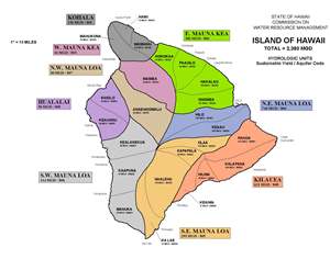 |
Ground Water Hydrologic Unit Map, Island of Hawai‘i. |
Hearing Schedule
|
Date
|
Action
|
|---|---|
| Oct. 3, 2019 |
The Commission held a public hearing to receive testimony on the proposed modification to the Hawai‘i Water Plan, as required under Chapter 174C, Hawai‘i Revised Statutes. The specific modification is to combine the Waimea (80301) and ‘Anaeho‘omalu (80701) Aquifer System Areas (ASA) into the Waimea-‘Anaeho‘omalu System/Sector Area (80302). This public hearing is a prelude to the actual Commission decision-making on the proposed action, which was tentatively set for Dec 17, 2019, but will be scheduled at a later date.
|
| Jun. 21, 2019 | Public Hearing Notice: Hawai‘i Water Plan Update – Water Resources Protection Plan Boundary Modification For Waimea And ‘Anaeho‘omalu Aquifer System Areas, West Maunakea And Northeast Maunaloa Aquifer Sector Areas Island Of Hawai‘i |
| Jun. 18, 2019 |
The Commission was briefed at its June Commission meeting.
|
| May 18, 2019 |
Presentation to I Mana I Ka Wai, Department of Hawaiian Home Lands Water Law and Advocacy Training, hosted by Department of Hawaiian Home Lands and Ka Huli Ao.
|