Keauhou Aquifer System Groundwater Adaptive Management Plan
About this Project
The Keauhou Aquifer System Area Groundwater Adaptive Management Plan (“Keauhou AMP”) is a pilot effort to monitor and protect the groundwater resources of the Keauhou aquifer system, along with the cultural practices and unique ecosystems along the Kona coast that depend on these resources. These Groundwater Dependent Ecosystems (GDEs) include anchialine pools, fishponds, and nearshore areas important for native ecosystems and Native Hawaiian cultural practices.
What Will the AMP Do?
The plan lays the foundation for:
- Monitoring: Establishing indicators and a monitoring plan to track the health of ecosystems and status of the aquifer.
- Decision-making: Informing whether new wells should be allowed, and under what conditions.
- Adjustments: Taking action based on changes in indicators like water levels and the midpoint of the transition zone.
- Learning: Incorporating more information, including monitoring data, to improve the plan over time.
- Stewardship: Sharing of the cost of monitoring and mitigating impacts to groundwater resources among those who use them.
Who Is Involved?
CWRM is leading the effort, with input from:
- An advisory committee of community and science leaders
- Working groups of experts in hydrology, Native Hawaiian traditional and customary practices, indicator species, and wastewater and pollution
- A public engagement process to gather insights from West Hawaiʻi residents and rights-holders.
When Will It Be Ready?
The first version of the plan—called a “first-generation” AMP—is being developed now and is expected to be approved by the Commission on Water Resource Management by November 2025. It will be updated in future years as more is learned.
For more information, see our Project Materials, literature list, and our past presentations.
Keauhou AMP Project Materials
These materials were created by Commission staff to help describe the Keauhou Adaptive Management Plan, and will be updated continually over the life of the project.
- Keauhou AMP Project Description (updated 8-6-2025)
- Keauhou AMP Outline (updated 7-2-25)
Expert Group Reports
Summary reports from the Hydrology, Indicator Species / Ecology, and Contaminants and Pollutants Expert Groups are available below.
Literature List
At the link below, we have provided a list of literature that will be used to inform the Keauhou AMP project.
To recommend other references for inclusion, please use the feedback form.
Kaloko-Honokōhau National Historical Park (KHNHP) Draft Adaptive Management Plan
The draft adaptive management plan linked below was developed by personnel from the National Park Service and Commission staff. While the plan itself was never finalized, it is an important building block and reference point for the regionally focused Keauhou AMP.

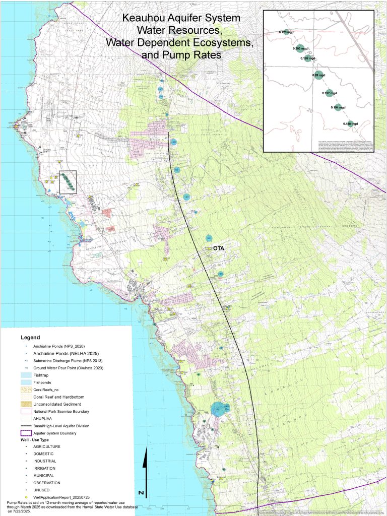
Map
The above map shows groundwater resources and wells in the Keauhou Aquifer System Area. Known locations of submarine groundwater discharge plumes, ground water pour points, anchialine pools, and other coastal and marine resources have been plotted. Also shown are pumping wells within the Keauhou ASA, with the size of each well proportional to its average pumping over the last 12 months. This map is a working draft; further input on the locations of resources is welcome via the feedback form above.
Presentations
| Date | Meeting Materials and Recording |
| August 19, 2025 9:00 a.m. DLNR Conference Room, Kalanimoku Building | Briefing C1: Update Regarding the Development of a First-Generation Keauhou Aquifer System Area Groundwater Adaptive Management Plan, Keauhou Aquifer System Area, Island of Hawaiʻi Meeting will be livestreamed on the CWRM YouTube page |
| July 15, 2025 9:00 a.m. DLNR Conference Room, Kalanimoku Building | Submittal B1: Requesting Approval to Proceed with the Development of a First-Generation Keauhou Aquifer System Area Groundwater Adaptive Management Plan Meeting will be livestreamed on the CWRM YouTube page |
| April 1, 2025 | Presentation by Deputy Director Ciara Kahahane Meeting Minutes Meeting Recording (Vimeo) |
Feedback
To provide input on any of the materials on this page, please use the feedback form below or access in a separate tab via this link.
