Water Management Areas
Water Management Areas are special areas where additional Commission regulation is required. This additional regulation is for owners of water sources (such as wells owners) who must obtain water use permits to withdraw water for various uses. Fundamentally, individual water management areas coincide with individual hydrologic unit areas.
View All Groundwater Hydrologic Unit Maps.
Click on the image to view or download a PDF of the Water Management Areas map.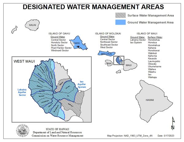
To become a designated area either the Commission or interested person must file a completed petition to initiate the designation process (View Petition for Water Management Area Action form). Various requests for government agency and public comments are an integral part of this designation process, which includes public hearings, reports, and is defined in 13-171, HAR. This process normally takes years before the Commission renders a decision.
If an area becomes designated, all existing and new source owners, with the exception of individual domestic users and those on rain catchment systems, must obtain a water use permit and justify their withdrawals and uses. To justify withdrawals, source owners must meet several criteria as is listed in 13-171, HAR, to obtain a water use permit. Various requests for government agency and public comments are an integral part of this water use permit process, which is also defined in 13-171, HAR. To date, the only ground water management areas reside on the islands of Oahu, Maui, and Molokai.
For a more complete historical explanation of governmental regulation of the development and use of water throughout the state, please see the chapter of Regulation of Development and Use under the Water Resource Protection Plan of the Hawaii Water Plan.
Island of Oahu
- North Sector
- Windward Sector
- Honolulu Sector
- Pearl Harbor Sector
- Central Sector
Island of Molokai
- West Sector
- Central Sector
- Northeast Sector
- Southeast Sector