10/31/13 – DLNR Announces Akule Fishing At Waimea Bay Oahu – Akule Fishing Open Nov. 1 – Dec. 31
Posted on Oct 31, 2013 in Aquatic Resources, DOCARE, Fishing, News ReleasesDEPARTMENT OF LAND AND NATURAL RESOURCES
News Release
| NEIL ABERCROMBIE GOVERNOR |
WILLIAM J. AILA JR,
CHAIRPERSON |
For Immediate News Release October 31, 2013
DLNR ANNOUNCES AKULE FISHING AT WAIMEA BAY OAHU
Akule Fishing Open Nov. 1 – Dec. 31
Click to download a PDF of this news release
HONOLULU — The Department of Land and Natural Resources (DLNR) announces the opening of akule fishing for Waimea Bay Ocean Waters from Nov. 1 to Dec. 31, 2013.
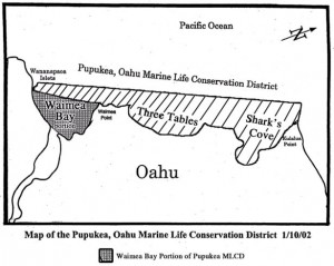
“Pupukea Marine Life Conservation District (MLCD) prohibits the take of marine resources, with the exception of the Waimea Bay portion of the MLCD. The Waimea Bay portion allows for poll and line fishing year round, as well as take of akule using net fishing methods during November and December,” explained BLNR Chairperson, William J. Aila, Jr. “These two months of the year provide fishers access to traditional akule fishing grounds. This period, along with the opelu period from August to September, provides access to the traditional net fishing grounds while conserving the marine resources within the rest of the MLCD.”
DLNR Division of Conservation and Resources Enforcement (DOCARE) will continue making periodic checks of the bay and actively monitor ocean activities. During this open period, Hawaii Administrative Rules provide regulations over the methods of fishing within areas of Waimea Bay. These rules balance the various fishing methods, such as poll and line or net fishing, by providing access to recreational and commercial users within Waimea Bay.
“DOCARE is here to ensure compliance with applicable state laws and regulations for both Commercial and Recreational fisherman alike,” said DOCARE Enforcement Chief, Randy Awo.
DLNR reminds fishers that:
- Akule may be taken with hook-and-line from the shoreline of Waimea Bay portion of the MLCD (HAR 13-34-3); “Waimea Bay” means that portion of the district bounded by an imaginary line from, and including, the Wananapaoa Islets across the mouth of Waimea Bay to Waimea Point.
- Must hook akule by the mouth; it is prohibited to “snag” akule (HAR 13-34-3 (1))
- No person may use more than two poles with one line per pole and with no more than two hooks per line (HAR 13-34-3 (1))
- Take of akule with legal nets pursuant to HAR 13-75-12.2.
- Motorized vessels, except sailing vessels with auxiliary engines, are prohibited in Zone ‘A’ of Waimea Bay ocean waters. (HAR 13-256-63(b)(1))
- Vessels with auxiliary engines shall be required to enter and leave Zone ‘A’ on sail power or by oar only.
- Any vessel anchoring within Zone ‘A’ shall be prohibited from anchoring within two hundred feet of the shoreline and shall anchor only in sandy areas.
- All vessels shall proceed at a speed of slow-no-wake, as defined in section 13-250-5, when in Zone ‘A’.
- Violations of these rules are petty misdemeanors (HRS 190-5, $250 first, $500 second, $1,000 third or subsequent)
Copies of the administrative rule are available at the Division of Aquatic Resources office, 1151 Punchbowl St., Rm. 330; in the Hawaii Fishing Regulations booklet (available at most sporting goods stores); or on the DLNR website: https://state.hi.us/dlnr/dar/admin_rules.html
# # #
Media Contacts:
Deborah Ward
Public information specialist
Phone (808) 587-0320
[email protected]
Laura Stevens
Education and Outreach Coordinator
Phone: (808) 587-0407
Fax: (808) 587-0390
[email protected]
Image of Pupukea-Waimea Marine Life Conservation District:
Background:
§13-34-1 Boundaries. The Pupukea Marine Life Conservation District shall include that portion of the submerged lands and overlying waters beginning at Kulalua Point extending seaward due west (270 degrees) to a point one hundred yards offshore at longitude 21_ 39’ 44” N latitude 158_ 03’ 89” W, then south to the most seaward exposed rock of Wananapaoa Islets on the southern side of Waimea Bay, including the Wananapaoa Islets at longitude 21_ 38’ 60” N latitude 158_ 03’ 50” W, then due southeast (135 degrees) to shore as further described in the “Map of the Pupukea Marine Life Conservation District, Oahu 01/10/02” attached at the end of this chapter HRS §190-3
§13-34-1.1 Definitions. As used in this chapter, unless the context clearly indicates otherwise:
“Waimea Bay” means that portion of the district bounded by an imaginary line from, and including, the Wananapaoa Islets across the mouth of Waimea Bay to Waimea Point.
§13-34-1.1 Definitions. As used in this chapter, unless the context clearly indicates otherwise:
“Akule” means any fish of the species known as Selar crumenophthalmus. This also includes the various life stages known as pa‘a‘a, hahalalu, halalu, and mau.
“Snag” means to engage in the act of pulling on a line that is attached to one or more hooks quickly enough across a fish for the purpose of hooking the fish anywhere except by the mouth. https://state.hi.us/dlnr/dar/rules/ch34.pdf


