Hā‘ena Community-Based Subsistence Fishing Area
| Location | The Hā‘ena Community-Based Subsistence Fishing Area (CBSFA) includes the waters and submerged lands from the shoreline to a distance of one mile off the northwestern coast of Kaua‘i, bounded by a straight line extending seaward at the boundary between Hā‘ena State Park and Nā Pali State Park, and a straight line extending seaward at the boundary between Hā‘ena and Wainiha, as shown. |
| Permitted | Pole spears 8 feet or less. Up to two fishing poles per person, with no more than two hooks per line. Throw nets. Pa‘ipa‘i net or surround gill net fishing methods, as long as the nets are deployed from shore or from a vessel less than 14 feet long. Two people must be within five feet of the net at all times while it is deployed. Scoop nets, but may not be used at night (between 6:00 pm and 6:00 am). Limit of three specimens of marine life may be taken with scoop net per day. Taking of limu by hand harvest only. Vessels with prohibited gear onboard may transit through the CBSFA as long as they remain outside the Vessel Transit Boundary (see boundaries below). |
| Prohibited | Fish feeding. Taking of live shells. Taking of live or empty shells while using SCUBA. Spear guns. Spearing at night (between 6:00 pm and 6:00 am). Lay nets. Selling or offering for sale any marine life taken from within the area. Possession of prohibited fishing gear, except outside the Vessel Transit Boundary. Taking, altering, defacing, destroying, possessing, or removing any sand, coral, rock, or other geological feature or specimen. |
| Bag limits | ‘Opihi, pipipi, kūpe‘e, and pūpū: limit of 20 total combined per day from the ‘Opihi Management Area only. Lobster: limit of two per day, hand harvest only. Urchins: limit of five per species per day. He‘e: limit of two per day; may be taken only by hand harvest or with a stick no more than two feet in length. |
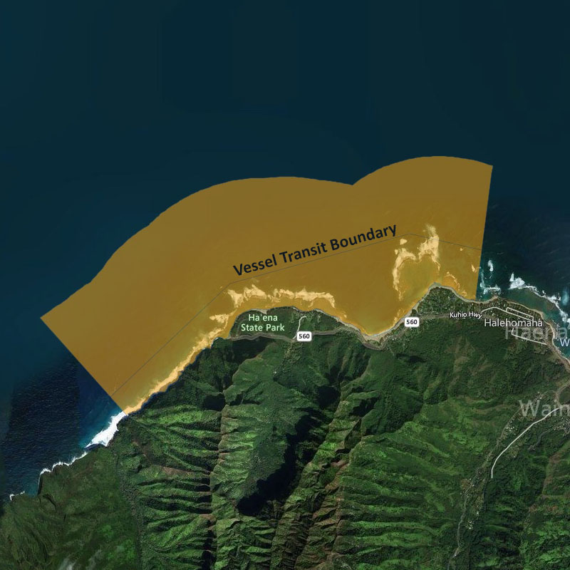
| Regulated areas | ‘Opihi Management Area Waters and submerged lands from the shoreline to a distance of 300 feet, from the Hā‘ena/Nā Pali boundary of the CBSFA to a line extending seaward at the western edge of Ke‘e Beach, as shown. Only place where ‘opihi, pipipi, kūpe‘e, and pūpū may be harvested, beginning December 1, 2017. Makua Pu‘uhonua Waters and submerged lands of Makua lagoon; a four-sided area bounded by straight lines between the points as shown, with the following coordinates. SW: 22013’33.88″ N, 159033’42.41″ W NW: 22013’41.15″ N, 159033’44.67″ W NE: 22013’44.57″ N, 159033’34.71″ W SE: 22013’38.26″ N, 159033’31.56″ W No entry without a special activity permit (applies to vessels and individuals). Vessel Transit Boundary Waters and submerged lands bounded by a line drawn along the CBSFA boundary from the shoreline between Hā‘ena State Park and Nā Pali State Park (Point “a”) at 22012’42.50″ N, 159035’44.50″ W to a point 1,000 feet offshore at 22012’49.98″ N, 159035’51.79″ W (VT1), eastward to a point 1,300 feet offshore at 22013’35.57″ N, 159034’59.73″ W (VT2), then to a point 2,300 feet offshore at 22013’55.42″ N, 159033’42.00″ W (VT3), then to a point 2,100 feet offshore at 22013’48.84″ N, 159033’10.76″ W (VT4), then along the CBSFA boundary to a point on the shoreline between Hā‘ena and Wainiha (c) at 22013’28.00″ N, 159033’13.50″ W, as shown. Allows vessels with prohibited gear onboard to transit through the CBSFA as long as they remain outside the Vessel Transit Boundary. This boundary does not affect general vessel operation or access to any area. |

