Kāʻanapali
Documents Library
Executive Summary Kāʻanapali Beach Restoration Project
Final EIS Vol I Kāʻanapali Beach Restoration and Berm Enhancement
Final EIS Vol II Appendix A - Cultural Impact Assessment
Final EIS Vol III Appendices B - Baseline Marine Biology and Water Quality; C - Marine Biology and Water Quality; D - Coastal and Marine Uses Report; E - Comments and Responses to EISPN
Final EIS Vol IV Appendix F - Comments and Responses to Draft EIS
Fact Sheet After Beach Nourishment
Fact Sheet Beach Change
Fact Sheet Beaches & Biology
Fact Sheet Benefits of Beach Nourishment
Fact Sheet Sand Quality
Fact Sheet Public Safety
Fact Sheet Sand Delivery
Fact Sheet Beach Access
Fact Sheet Cultural Impacts
April 2022 Request for Proposals
April 2022 Contract Specifications and Plans
April 2022 Kaanapali Beach Plans
May 2022 Addendum 1
Informational Briefing
A public online informational meeting was held on September 24, 2020. The video recording is online on OCCL’s Video Channel.
Kāʻanapali Beach Restoration Project: Executive Summary
Kāʻanapali Beach has been negatively impacted by chronic erosion and extreme seasonal erosion over the previous four decades. The rate and severity of damage has accelerated likely due to sea level rise and recent record high water levels. Sand loss from the natural beach systems, or littoral cells, is expected to continue and likely accelerate with sea-level rise. The beach may be conserved with sand nourishment or managed retreat or a combination of approaches, but managed retreat is a long-term action that does not address chronic beach loss happing now. Managed retreat is a multidecadal process, requiring years of planning, funding, and implementation. As a synergistic mid-term step in a much longer adaptation process, the beach can be restored through sand nourishment utilizing sound engineering design and best practices to ensure protection of the nearshore marine environment.
Beach restoration is a specific type of environmental restoration, focused on restoring coastal sandy habitat that extends across the terrestrial/marine boundary. In broad terms, environmental restoration is focused on the renewal of a damaged resource, typically after the resource has been damaged due to human interactions. Modern sea level rise is a result of human-induced global atmospheric and ocean warming. Changes in storm severity have also been attributed to climate change. Moreover, these phenomena are identified as key drivers in accelerating erosion rates in Hawaiʻi and globally. As such, beach restoration is an important and viable environmental restoration technique to be deployed as part of the suite options needed to adapt to long-term changes in climate, the ocean, and our shorelines.
The State of Hawaiʻi and the Kāʻanapali Operations Association, Inc. have developed a plan to ensure the viability of this sandy coastal resource, which includes both beach restoration and berm enhancement. Beach restoration is proposed for the section of beach between Hanakaʻōʻō Beach Park and Hanakaʻōʻō Point (“Hanakaʻōʻō Littoral Cell”), and beach berm enhancement is proposed for the section of beach between Hanakaʻōʻō Point and Puʻu Kekaʻa (“Kāʻanapali Littoral Cell”) (Figure 1). The proposed project is intended to mitigate the impacts of rising water levels and coastal erosion, which are increasing with global sea level rise.
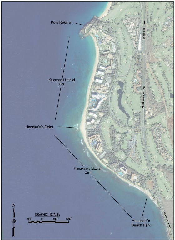
Figure 1: Kāʻanapali Beach overview
The project provides a nature-based adaptation solution that restores natural habitat and recreational resources while increasing coastal hazard mitigation and protection for the Kāʻanapali Resort community as an interim, mid-term approach while long-term adaptation options are developed. Adding beach quality sand to the north and south littoral cells is a key action for restoring the beach back to its former width and volume to make Kāʻanapali Beach more resilient to the impacts of coastal erosion and high wave overwash.
The Hanakaʻōʻō Littoral Cell is suffering from a combination of chronic and episodic erosion, which has resulted in beach narrowing, shoreline recession, reductions in beach access, and damage to backshore infrastructure including the Kāʻanapali Beachwalk. The beach in this littoral cell is less seasonally dynamic than the beach in the Kāʻanapali Littoral Cell to the north; however, the long-term changes in beach location and width are more persistent along this length of shoreline than in the Kāʻanapali Littoral Cell. The presently narrow beach, chronic erosion, and limited seasonal sand transport make this section of shoreline suitable for beach restoration. Beach restoration would include the addition of beach quality sand from the current beach face out to the former extent of the beach in the 1980s. This part of the proposed project would use approximately 50,000 cubic yards of highly compatible marine carbonate sand to restore the beach to the approximate position shown in the 1988 aerial photograph. This would widen the dry beach by between 41 and 78 feet (Figure 2).
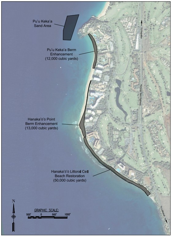
Figure 2. Kāʻanapali Beach restoration and sand recovery areas overview.
The Kāʻanapali Littoral Cell, between Hanakaʻōʻō Point and Puʻu Kekaʻa, experiences significant seasonal erosion with alternating predominant wave directions in summer and winter. Berm enhancement, or raising the elevation of the beach berm, would create a new reservoir of sand along the backshore (the upper, usually dry area of the beach) to augment the current sediment system with additional volume. This additional volume of highly compatible sand will help offset temporary beach loss during the natural seasonal erosion cycles. Sand placed at the north end of the beach would be seasonally eroded during the winter months, while sand placed at the south end of the littoral cell, at Hanakaʻōʻō Point, would be released during summer months. Both berm enhancement areas would provide a buffer during extreme erosion events by increasing total beach sand volume within the broader littoral cell. This part of the proposed project would use approximately 25,000 cubic yards of sand to raise the beach berm elevation by 3.5 feet along most of the Kāʻanapali Littoral Cell (Figure 2). The berm enhancement area would extend from the vegetation in the backshore to the berm crest, at the mauka edge of the beach face.
A total of approximately 75,000 cubic yards of sand is needed for the proposed beach restoration and berm enhancement project, with 50,000 cubic yards and 25,000 cubic yards allocated to the Hanakaʻōʻō and Kāʻanapali littoral cells, respectively. The beach quality sand proposed for recovery from an 8.5-acre sand deposit is located from approximately 150 feet to nearly 800 feet seaward of Kāʻanapali Beach. This sand area, in 28 to 56 feet water depth (Figure 2), is part of a much larger regional sand field fronting Kāʻanapali.
Sand compatibility between the recovery site and the active beach is one of the most important aspects of beach restoration. High compatibility helps to minimize the potential for negative water quality impacts from fine sediments associated with beach restoration, while maximizing the stability or equilibrium of the beach with typical wave conditions. Moreover, the offshore sand’s similarity to the adjacent beach sand is likely a result of transport and loss from the active beach system, meaning this project is likely returning beach sand back to its beach of origin.
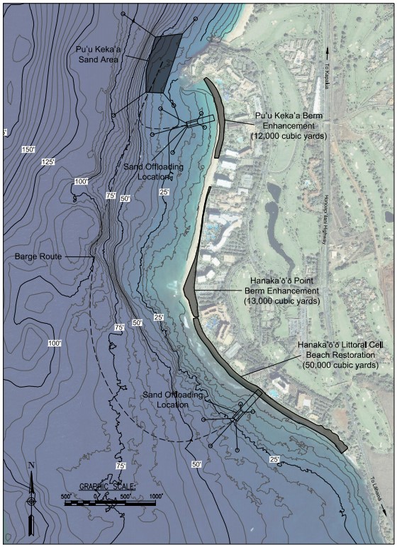
Figure 3. Kāʻanapali Beach restoration sand delivery plan
The proposed sand recovery method consists of a moored crane barge equipped with an environmental clamshell bucket, two sand transport barges, several tugboats, and two landing areas at opposite ends of the project area. The crane barge would lift sand from the seafloor with the environmental clamshell bucket and place it onto two approximately 1,500 cubic yard capacity barges. Environmental clamshell buckets are designed to minimize water volume and maximize precision with each sand recovery scoop, which minimizes potential impacts to the surrounding environment. The sand transport barges would rotate between the sand recovery site and the off-loading sites. Once a sand transport barge is filled at the sand recovery site, it would be towed to the off-loading site by a tugboat, where the barge would be moored adjacent to an elevated trestle or floating bridge (Figure 3). The elevated trestle or floating bridge would extend from approximately 15 feet of water depth to shore. Sand would be transferred from the barge to shore along the bridge/trestle system using a methodology selected by the contractor. Land-based equipment would then transfer the sand from the shoreline, at the end of the elevated trestle or bridge, to the placement area. At the sand placement area, which would move each day as the project advances, bulldozers and crews would spread sand along the shore to meet the lines and grades of the design beach restoration plan and section and the berm enhancement plan and section. Sand would be placed over the existing beach and no excavation of the beach is planned with the proposed project.
During placement activities there would be heavy equipment operated on the beach at the sand transfer site and at the sand placement site. These areas would be treated as active construction sites and public access would be limited near the heavy machinery and sand loading and grading areas. The sand placement site would move progressively through the berm enhancement and beach restoration areas as sand is added to the beach. Sand would be mechanically hauled by dump trucks between the two transfer sites on the beach and the restoration areas on the berm and beach. During hauling operations, the transit corridor for the trucks would be cordoned off and assistants would be available along the full length of the haul route to facilitate public access to and from the shoreline. While sand transport barges are transiting from the sand recovery barge to the off-loading sites, marine traffic and public access along the navigation route would be restricted. There would be approximately four rotations of barges between the recovery site and off-loading sites each day. There would also be restricted public access around the sand recovery barge and the offloading sites, to protect the public from potentially dangerous contact with the equipment and support materials.
Beach restoration is expected to last approximately two months, including sand recovery, transfer, and placement activities, which are expected to take place at least 12 hours per day, seven days per week. The goal is to complete the project in the most efficient manner possible, thereby limiting the inconvenience to the general public and construction related impacts to the environment. The work is projected to take place during October, November, and part of December, minimizing overlap, as much as possible, with southern summer swell and northern winter swell environments.
Other forms of beach nourishment are also effective, have been utilized within the United States and on international coastlines, and may work at this location. Use of other means and methods for beach nourishment at Kāʻanapali would be contingent on the feasibility of given site conditions and on receiving permits from the applicable Federal, State, and County agencies. An alternate sand recovery and transport technique is hydraulic dredging, where sand entrained in seawater as a slurry is delivered via a pipeline to the beach or the inshore waters directly adjacent to the beach. Additional methods include, but are not limited to, sand transfer in submerged pipelines to create submerged sand bars, mechanical placement on the beach through conveyor belts, and dune creation or restoration. Sand placed in nearshore and connected features are spread throughout the beach and inshore sand field by natural wave and current processes.
The State has developed extensive best management practices through the environmental review process and consultation with natural resource management agencies to ensure that coral and other marine organisms and resources are protected throughout project construction. Identification of a beach compatible and suitable sand source is a critical element of the marine protection program. The sand selected for this project is a nearly ideal match to the native beach. The compatibility, in terms of the sand’s physical characteristics and quality, between the proposed sand source and the beach exceeded all other sand sources investigated during this project. Moreover, high compatibility between restoration sand and native beach sand has been shown to result in faster equilibration and more natural response of the restored beach, as well as minimization of potential long-term negative impacts that may occur with beach restoration projects. In addition, the sand recovery site is nearby, which limits travel and sand transfer requirements.
The proposed project represents an effective and beneficial step in coastal adaptation to sea level rise. Beach restoration is a nature-based ecosystem restoration project that is designed to improve mid-term ecologic function, cultural and recreational resources, and coastal hazard mitigation. The beach may be restored in the mid-term with sand nourishment, while managed retreat is investigated as a long-term response and adaptation practice. Likely, the future of coastal management in Kāʻanapali, and Hawaiʻi as a whole, will require a combination of approaches including both of these and more. For now, managed retreat is a long-term action to be developed and implemented in the future, and beach restoration is an achievable target for early success in adaptive coastal management.