04/26/22-NEW DASHBOARD PUTS ENVIRONMENTAL STEWARDSHIP PROJECTS ON THE MAP
Posted on Apr 26, 2022 in Forestry & Wildlife, Main, Media, News Releases, sliderNews Release
| DAVID Y. IGE GOVERNOR |
SUZANNE D. CASE
CHAIRPERSON |
For Immediate News Release: April 26, 2022
NEW DASHBOARD PUTS ENVIRONMENTAL STEWARDSHIP PROJECTS ON THE MAP
Mapping effort aims to increase collaboration and identify stewardship gaps
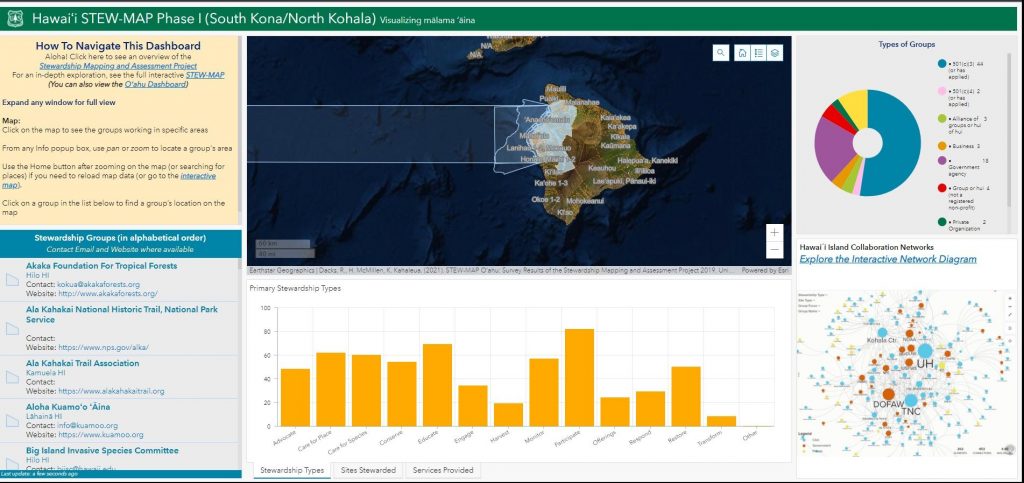
(Honolulu) – Who takes care of the landscapes and seascapes across Hawaiʻi? Where do stewardship projects overlap, and where are there gaps? To address these questions, the Kaulunani Urban and Community Forestry Program, a DLNR Division of Forestry and Wildlife (DOFAW) program announces the launch of the online interactive Stewardship Mapping and Assessment Project (STEW-MAP).
STEW-MAP identifies and maps the diverse range of stewardship groups working across the landscape. An interactive map and dashboards display who stewards the area, primary methods of stewardship, site and group types, and services provided by the groups. Interactive network diagrams are also available, displaying how stewardship groups are connected to one another in a larger network of care. STEW-MAP was conceived of and supported by the USDA Forest Service, the Kaulunani Urban and Community Forestry Program, the University of Hawai‘i at Mānoa, and a panel of community-based stewardship groups.
“We are pleased to collaborate with the State of Hawai‘i and their partners on stewardship mapping. The project teams have demonstrated how this approach can be used to support aims of equitable and inclusive community forestry,” said Lindsay Campbell, Research Social Scientist, USDA Forest Service, Northern Research Station.
STEW-MAP Hawai‘i currently includes two geographic focal areas: Hawaiʻi Island (North Kona and South Kohala districts) and Oʻahu (Kona and Koʿolaupoko districts). The project team inventoried stewardship groups and mapped their networks with the goal of strengthening capacity. In total, 245 groups were surveyed, representing 2000 volunteers, 4833 staff, and well beyond $143 million in annual budgets. These groups also identified almost 1000 unique collaborators in their environmental stewardship work.
“Our community of environmental stewards is profound!” said Heather McMillen, a Forester with DOFAW and an affiliate faculty member at the University of Hawai’i at Mānoa. “These online tools highlight the sometimes invisible yet highly valuable work of community members who care for the lands, waters, special places, and lifeforms of Hawaiʿi.”
Survey results reveal a great diversity in the scale of stewardship efforts— from stewarding a single garden to working across entire coastlines and forest reserves. The project also documented a vast network of projects ranging from local to international land and seascapes.
“STEW-MAP has identified groups who focus on environmental activities as well as as education and cultural practices,” said Rachel Dacks, STEW-MAP Postdoctoral Fellow and lead researcher at the University of Hawai‘i at Mānoa. “Environmental stewardship is a means to support holistic community well-being as well as environmental health.”
Users interested in STEW-MAP can attend a Facebook Live demonstration on how to use the dashboard and map on Monday May 2, 2022, at 1:30 pm on the Kaulunani Facebook page.
# # #
(All images courtesy: DLNR)
STEW-MAP website: https://www.nrs.fs.fed.us/STEW-MAP/
Kaulunani Facebook Page (for May 2 livestream): https://www.facebook.com/Kaulunani
Kaulunani Urban & Community Forestry Program website:
STEW-MAP technical report: https://www.nrs.fs.fed.us/STEW-MAP/oahu/pubs/
Media contact:
AJ McWhorter
Communications Specialist
Hawai’i Department of Land and Natural Resources
[email protected]
808-587-0396 (Communications Office)